Additional Documents:
  
|
 |
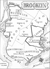
Map of Brooklyn in 1700
This map shows the original six towns of what is now Brooklyn. The earliest recorded land purchase by the Dutch, in the area of what is now Flatbush and Flatland, was recorded in 1636. The Dutch West India Company encouraged town organization and soon the Dutch settlements of Breuckelen, 1646 (Brooklyn), New Amersfoort, 1636 (Flatlands), Midwout, 1652 (Flatbush), Boswick, 1661 (Bushwick), and Gravesend, 1646 (settled by the English), were recognized as towns. During the 17th and most of the 18th c. Brooklyn and its sister towns were small farming communities with little commerce outside their borders. In 1664, the English demanded the surrender of New Amsterdam (Manhattan), but English rule made little difference to the towns until the 18th century, with the exception, in 1683, of placing the original six towns under an administrative entity known as Kings County. Of all the towns, Brooklyn grew the most rapidly through the gradual annexation of the other towns, and because of its proximity to the river and to Manhattan. The great population and economic growth of Manhattan spilled over into Brooklyn. In 1898, Brooklyn was consolidated with Manhattan (along with the Bronx, Queens and Staten Island) to form New York City.
To see a map of the city of Brooklyn in 1863, view Document 51.
Citation - Document 1
1700
Brooklyn Public Library – Brooklyn Collection
www.brooklynpubliclibrary.org/civilwar
|
|